Background
Forests and well-vegetated rangelands/pasture lands play an important role in protecting watersheds and in preventing the flooding of plain areas of the river basins through regulating water flows (in terms of timing, quantity, and quality). These also protect landscapes, infrastructure, and soil by preventing, controlling, and minimizing landslides and erosion. Therefore, this policy brief identifies, assesses, quantifies, and evaluates the forest ecosystem pertaining to the soil and water conservation services. For the purpose, this study utilized the secondary data sets obtained through satellite imagery and the published documents in the form of research papers, reports, etc. It assessed, quantified, and valued the forests ecosystem services for protecting watersheds and water reservoirs by preventing soil erosion and retaining sediments, respectively. With this viewpoint, the study identified and assessed catchment areas of the ten major reservoirs in the country, including Diamer, Gomal, Hub, Mangla, Tarbela, Warsak, Khanpur, Sabakzai, Satpara, and Mirani.
Watersheds vis-à-vis Forests
The total area of studied watersheds in Pakistan is estimated at 65812800 ha. Out of which the area of forests is estimated at 1,548,961 ha of the watershed land, which contributes to saving lands from erosion. While grasslands/rangelands within these watersheds are estimated at 18,520,224 ha, which provide great potential for not only livestock production but is also of great value for sediment retention to water reservoirs in the country in terms of saving re-silting costs of dams. Within these ten watersheds, the bare lands are estimated at 12,766,110 ha, which are heavily contributing to soil erosion and the flow of soil sediments to water reservoirs.
Soil Erosion and Sediment Retention
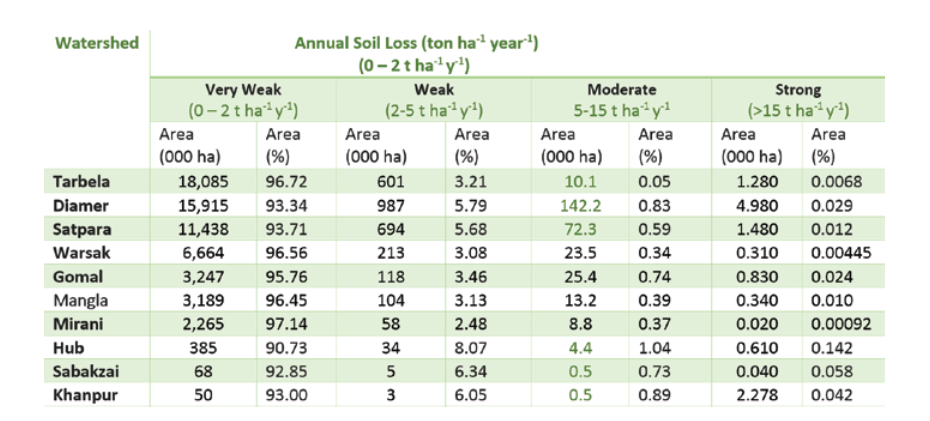
The total land with heavy soil loss (i.e., >15 t ha-1 y-1) has been estimated at 10000 ha in the ten watersheds of the country, whereas 300,995.45 ha of land has been estimated that is facing moderate to high soil erosion (i.e., 5-15 t ha-1 y-1), mainly on the bare and grasslands in these watershed areas. The process of soil erosion has been started on 2,816,133.49 ha of land presently with a weak erosion rate (i.e. 2-5 t ha-1 y-1) that needs to be conserved on an emergency basis.
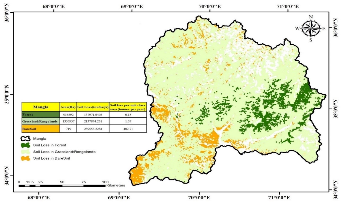
The forest ecosystem services in all the ten watersheds prevented soil erosion and retained sediments to protect water reservoirs. However, for the purpose of the policy brief, we present here the study results obtained for the Mangla dam. About 27.13% (916892 ha) of the total area of the Mangla watershed contains forests. The soil loss per unit forest class (0.15 tons per year) is significantly lower than that for the bare soil class (402.71 tons per year). Taking the treatment cost of eroded soil in the US ($7.03 per ton of soil), only the forest areas mapped in the Mangla watershed saved about $5,475,814 in preventing soil loss. Large vegetation cover on upstream watershed areas contributes to an ecosystem service for retaining sediments to flow in water reservoirs. The total vegetation cover is more elevated than bare land, indicating high sediment retention for the Mangla Dam, which is contributed by 70% of the vegetation classes’ watershed area.
Figure 13: Forest classes identified in the delineated catchment area of Mangla dam; Contribution of forest and rangeland/pasture classes to soil erosion stoppage
Recommendations
The following recommendations are made to materialize the non-timber contribution of forests in terms of echo system services.
- For all the ten watersheds in the country, more than 90% areas are in the very-weak range of soil erosion, which can eventually be triggered to higher erosion levels. Moreover, it is observed that the vegetative cover in all watershed areas decreased the annual soil loss. It is, therefore, recommended to increase forest areas in all the watershed.
- The identified forest gaps in the watershed areas have the potential of extending the mega plantation projects in the country like the Billion Tree Afforestation Project in Khyber Pakhtunkhwa and the Ten Billion Trees Afforestation Project to these huge bare lands. The average avoided erosion value in such planted forests can be approximately 372.64 per hectare.
- Reducing bare soils in the catchment areas can significantly reduce nutrient flow into the water reservoirs.
- Rising forest levels upstream of the pivot point (dam) will enormously reduce the de-silting costs of all developed and under-development dams.
- Indirect methods to quantify the forest’s ecosystem services are valuable to initially recognize the indirect economic value of forests. The directly quantifying of the exact contribution of these forest ecosystem services is a multi-year process, which was not possible within the stipulated time of the present project. Such accurate evaluations of forest ecosystem services will help raise funding to initiate afforestation projects.
References
- Zokaib, S., & Naser, G. (2011). Impacts of land uses on runoff and soil erosion A case study in Hilkot watershed Pakistan. International Journal of Sediment Research, 26(3), 343-352.
- Haq, I. (2015) Management of Tarbela Reservoir, 72nd Annual Session of Pakistan Engineering Congress. Paper No. 733, pages 17-42.